

By Robb Turner
Many readers who have enjoyed the garden tour at Southern Highlands Reserve will remember that most of the rock there was hauled up the mountain to the garden from Elberton, GA, Robbinsville, and other locales in North Carolina. That’s because there is very little native rock accessible at or near the surface of the Reserve’s 120 acres. This may seem odd for a mountaintop location about 4,350 feet above sea level. I assumed Toxaway gneiss was the rock holding up Toxaway Mountain and underlying SHR but quickly realized the picture is rather complicated.
Toxaway gneiss is a 1.15-billion-year-old rock that was formed as a granitic igneous intrusion or pluton in Rodinia, the supercontinent that existed before Pangea. Toxaway gneiss has been highly metamorphosed at great temperatures and pressures and typically is found as a very hard, light colored rock of quartz and feldspar with distinct dark banding of mica. There also is an “augen” phase that has small “eyes” of feldspar and quartz in it. Toxaway gneiss holds up Toxaway Falls and the Toxaway Dam and Lake. It is freshly exposed in the new road cut on Highway 64 just east of the Falls. Toxaway gneiss is quarried for roads and other uses from the McNeely quarry on Highway 281 South toward Whitewater Falls (also on Toxaway gneiss) and thus is now one of the most widely distributed rocks in this region.
So, what rock types then hold up Toxaway Mountain and underlie SHR? Most of the geological material for this article is drawn from two sources, a very in-depth master’s thesis by a student at University of Tennessee (Jubb 2010) and a very readable book on the geology of the area, Whence these Special Places (Jacobs 2019). I highly recommend the latter for those who’d like to know more than can be said in this short article.
Toxaway Mountain and SHR are shown in the lower center of Figure 1 in the middle of a folded band of metamorphic rocks shown in gray, brown, and light blue on the geologic map. They are described as the Tallulah Falls Formation by Jubb and as the Ashe Metamorphic Suite (or AMS) by Jacobs. These metamorphic rocks were formed from sand, silt, and mud that were weathered and eroded from supercontinent Rodinia mountains and then deposited as deep sediments in the Iapetus Ocean (between the future Africa and North America) after Rodinia broke up. Beginning about 500 million years ago when the Iapetus Ocean began to close again, these sediments (by then sedimentary rocks) were pushed together and to great depths by the colliding tectonic plates.
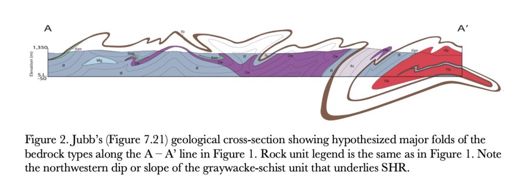
By about 340 million years ago what is now Africa had run into what is now North America, forming Pangea and a high (and deep) mountain range rivalling today’s Himalayas. During that time the deeply buried sedimentary rocks metamorphosed under great temperature and pressure into gneisses (rocks with distinct banding) and schists (rocks with plate-shaped mineral grains that can be observed without a microscope). Their composition, texture, and hardness vary depending on the degree of metamorphism, source rock, and deformation history. Geologists see evidence in these rocks of at least six periods of deformation that occurred between 500 and 175 million years ago when the Atlantic Ocean started opening. The geologic term for these rocks is a mélange. Jacobs calls them a “jumble” and “mishmash.” The sharp lines between members of the formation shown on the geologic map may be deceptive. The mixed-up reality may be inferred from the hypothesized deformation shown in the cross-section A – A’ in Figure 2, and from trying to identify and separate these units in the field.
A third distinct rock type is found in the immediate area. This is the Whiteside granitic pluton that was intruded into the Talullah Falls Formation rocks while they were deeply buried about 466 million years ago. Shown in purple in Figure 1, it has been partially metamorphosed into gneiss and underlies nearby Cold Mountain, Panther Tail, and Little Panther Tail Mountains as well as most of Panthertown Valley including Little Green and Big Green Mountains. These areas exhibit classical plutonic rounded mountain tops and smooth exfoliating mountainside cliffs. A small sliver of the Whiteside plutonic rock is mapped just to the east of SHR but does not appear to underlie the property.
The rocks underlying SHR include graywacke-schist, which consists of light to dark gray, medium-grained biotite gneiss with interlayered biotite (dark, iron rich mica) and muscovite (light-colored, iron-poor mica) micaceous schist. (Graywacke is the sedimentary mixed sand/silt/mudstone parent from which these gneisses and schists were metamorphosed.) As previously mentioned, very little of this rock is exposed for us to see. Interlayered gneiss and schist can be seen exposed under the Duke Power lines that cross the upper part of the Reserve. It is fine-grained, hard, and slow to weather. The micaceous schist can be seen sparkling in thin interlayers in the gneiss but is more prominent in several locations in the stream bed leading to Vaseyi Pond where the overlying soil has been scoured away. The schist is coarser-grained, distinctly foliated, and weathers more quickly. Both the gneiss and schist layers are also exposed on the cliffs on the southeast slope below and to the west of the power lines and in a very few places along SHR core-area trails. You can tell the native rock that is in place by its characteristic sloping dip to the northwest, on the ground and as shown in the cross-section in Figure 2.
Also occasionally found on SHR are rocks with very large crystals of quartz, feldspar, and most notable, mica. These are called pegmatite and occur in veins within the gneiss and schist. They were injected sometime after the gneiss and schist were formed, but while they were still hot. Slow cooling of the pegmatite allowed time for the huge crystals to form. A large vein of almost pure quartz cuts across SHR near the top of the Vaseyi Trail. A huge boulder of almost pure quartz sits by the trail, and other large pieces from this vein can be found in and down the stream bed, as well as in the stream bed behind Jack’s Barn and the greenhouse.
Under our generally dense temperate rain forest, the rocks can weather into gray and brown saprolite. Sometimes this is seen along roadsides or construction sites. The weathered material typically retains the banding or layering of the parent rock, but it can be cut through by a backhoe or bulldozer. As tree roots, burrowing organisms, and percolating dissolved matter penetrate the material, the saprolite becomes soil and characteristic soil horizons form. If the saprolite is exposed, it can quickly erode and become the sand we often see on trails or in sandbars along streams of the area.
Although Toxaway Mountain and SHR are not held up by the ancient Toxaway gneiss, they are underlain by another, half-the-age micaceous gneiss that is also capable of holding up high mountains. The topography of the area around SHR seems to be influenced more by fracture zones or other structural factors than by the type of underlying bedrock per se, but the bedrock, topography, and high-rainfall temperate climate all combine to build soils and microclimates and habitats supportive of an extraordinary diversity of native plants and animals.

See more photos and descriptions here.
References:
Jacobs, William S. 2019. Whence these special places? The geology of Cashiers, Highlands, and Panthertown Valley. Great Rock Press, Asheville NC. Available from numerous local retailers and www.greatrockpress.com.
Jubb, Mary Grace Varnell, “Paradoxes in the deformational and metamorphic history of the eastern Blue Ridge: Evidence from the Lake Toxaway and eastern Big Ridge quadrangles, North Carolina.” Master’s Thesis, University of Tennessee, 2010.
https://trace.tennessee.edu/utk_gradthes/638
Robb Turner is a PhD geologist who worked for Oak Ridge National Laboratory and Oak Ridge Associated Universities studying and advising federal agencies on energy and environmental issues ranging from contaminant transport and fate to conservation of endangered species. He grew up gardening with his grandfather and developed a passion for plants, both native species and horticultural varieties, and an understanding of their place in diverse landscapes. Robb is retired in Lake Toxaway with his wife, Sybil, and two dogs. He enjoys hiking, camping, and photography, and visits every garden and natural area he can.